On the road, In the air
This is what their patches claim and I have yet to argue. I have been very fortunate this season to get a chance to travel out to several field camps in the surrounds of McMurdo. Antarctica from the air is quite an experience whether out the window of a C-17, C-130, or from the great hovering and spinning magic carpet ride that helo ops offers. I had never ridden in a helicopter before working in McMurdo, and now that I have ridden in them quite a few times, the magic never wears off. A lot of human inginuity and combustible fuel allow us to travel in the realm of storybook imagination, what was once merely creative vision is now (and has been for some time) a reality of transportation, often taken for granted from afar, but somehow endlessly captivating to be involved in.

Some of the nooks and crannies of Ross Island from high in the sky.
Lots of marine and seal grantees call these smaller islands home.
For science in Antarctica, transportation is the name of the game, and as much as any of us are carpenters, divers, dining attendants, or physicists we are dominated by the logistics of how we can do what we do while we are here. In old times expeditions were measured in years instead of months or weeks, travel by ski or dog was the norm, and the samples collected along the way literally weighed heavy on the backs of some who didn't even make it out alive.

These three folks made it out alive, but not without persisting through
enough bad weather to play 22 games of checkers.
Today we zip down here in commercial jets, with air-force support, fly around the continent in dependable (fairly) planes, and explore the nooks and crannies in a moment's notice from the helicopter.
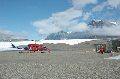
Two trips I have taken this season brought me farther into the dry valleys than I had ever been before, and to the highest heights of the volcanic island we reside on. These trips are all taken at the beginning of the season to "Open" these sights. This involves ensuring life support (stoves, buildings) is functional, fixing problems we find with the structures, and sometimes, Lots and Lots of shoveling
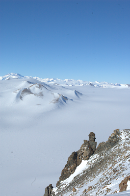
Two views from the same spot on Mt. Newell. On the left the Wright Valley and Lake Vanda - fed by the Onyx Stream. On the right, a very different reality of pure glacier on the way to the antarctic plateau.
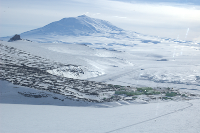
My trip to open the huts at Bull Pass and Mt. Newell took me over some beautiful areas and to the top of a mountain with a view spanning mountain ranges, the ice plateau, the Ross Ice Shelf, the open water of the southern ocean, and of course our little town down on the tip of Ross Island, in the shadow of the great Mt Erebus.
Bull Pass consists of two small huts. One is for small bands of Geologists to utilize and the other is one of several CTBT (Comprehensive Nuclear Test Ban Treaty) sites on the continent. It is a self-supporting monitoring station with it's finger to the seismic wind deep in the granite below. Along with over 100 counterparts, it helps sense possible nuclear bomb tests all over the world. Amazing! I found this website interesting when I looked to learn more about this:
www.ctbto.org
A fly over of lake Vida to photograph conditions for a future camp brought us into the next valley, and to the conclusion of our work for the day.
At 12,500 Ft. Mt Erebus makes Ross Island the 6th tallest island in the world. That's right, we sit on a hot spot! (who would have guessed?)
With a relative altitude of 13,600 at the Lower Erebus Hut, and ~14,000 at the rim it makes for qutie an adventure to open from sea level. Around here, things are not always how they appear on your topo map, and the cold cold air in the atmosphere lowers our air pressure to the degree that it ususally adds over 1000 feet to our physiological altitude.


A blind camera shot from the back seat!; Looking down, the landscape opens up quite literally. Crevasses like this one cover the island, but many are invisible.
The first to arrive at the hut after a winter of scouring winds, sulfurous air, and the ever-present drifting snow is an adventure worth bringing a shovel for. Luckily after the helo drops you and your equiptment off, and you catch your breath from unloading all of it, you get a chance to warm up digging steps into the snow berm to allow safe passage down to door level in the -30 degree warming October weather.
The huts are drifted up to their roofs on one side, and are slowly deteriorating from the scouring wind on the other. It speaks well to the impermanence of human impact.
Ok, ok it is only COMPLETELY buried on one side.
The wind scours the other side so much we can barely keep a coat of paint on it!
The wind scours the other side so much we can barely keep a coat of paint on it!
The only other sign of humanity in the area is a downed ship just a bit off to one side of the area around the huts. A coast guard Helicopter that got into some trouble up here decades ago.
Opening the huts involved lots of shoveling, firing stoves, shoveling, uncovering windows, shoveling, hanging weather insturments, shoveling, getting the solar panels out of the garage, shoveling, and a healthy dose of removing drifts from inside the buildings. It is really amazing how much snow accumulates blowing through the tiniest crack you can imagine.The area around the hut is covered in rock outcrops thick with crystals
which solidify in the rocks that spew from the cone on occasion.
which solidify in the rocks that spew from the cone on occasion.

Fumurols dot the landscape as well as heat from the volcano melts away at the cold desert snow. Antarctica's humidifiers!

http://en.wikipedia.org/wiki/Mount_Erebus


